Coldest, driest and sunniest yet recorded - record number of frosts recorded
April continues to be the month that gives - 2020 was glorious and in many ways, but with subtle differences, so has 2021.
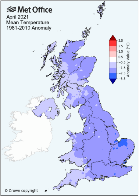
Both have been remarkably dry and sunny, but whilst 2020 was pleasantly warm, 2021 has been cold with a record breaking amount of frost, although it hasn't finished as the coldest on record in Cumbria **.
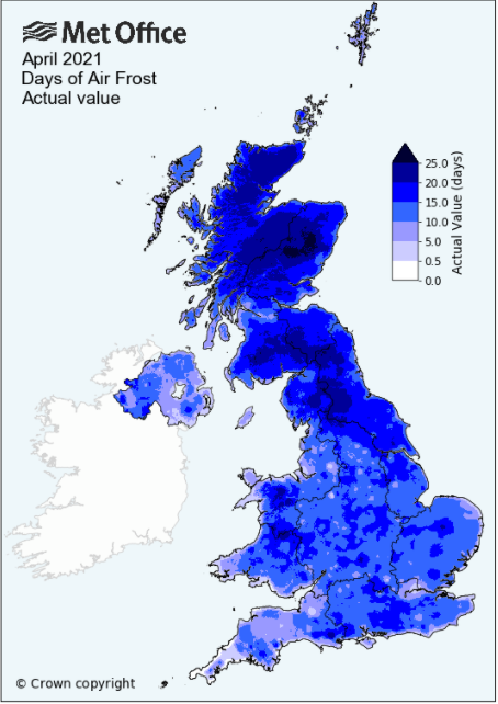
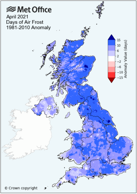
High pressure was very much to the fore throughout the whole of the month and whilst its position did alter throughout the month, the majority of the time it drew in either a cold Arctic air mass or an E-NE'ly airflow. That cold air flow, coupled with calm conditions and clear skies was the perfect recipe for frost to develop and with 20 air frosts and a mean minimum temperature well below zero, record breaking.
With the Arctic airflow, especially in the first half of the month, some of the frosts were severe and certainly the lowest in my 12 years of records, but the frequency and severity were notable and certainly very disruptive to agriculture and gardeners alike. However, come April the sun is strong and in the second half of the month, whilst cool nights still prevailed, day-time temperatures under sunny skies did rise above average with some of the days being pleasantly warm and at Brampton 237 hours of direct sunshine is a new record for April, replacing that of 2020!
At Newton Rigg 20 air frosts and 22 ground frosts were recorded and this creates a new record for the highest number of frosts in April - replacing the record set in 1922 of 15 air frosts and 18 ground frosts. Whilst only estimated, the mean minimum temperature this month at Newton Rigg is -0.8°c and which is a new record for the lowest mean minimum and is only the third time that April has seen this parameter below zero.
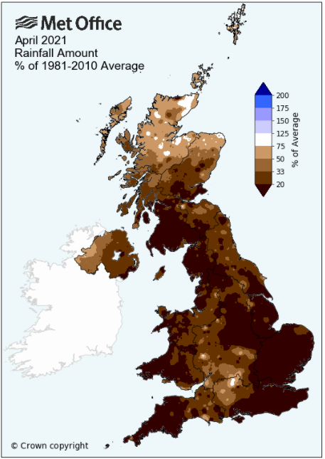
The dryness of the month was also notable making it one of the driest on record, variably the driest since either 1980 or 1974 and it was only a little rain in the final few days of the month that pushed the final totals just above 10 mm.
MSLP of 1024.8 Mb was +11.1 MB above the local average for the month and overall a mean minimum of -0.88°c and a mean maximum of 11.22°c saw the temperature -2.77°c below the twelve year average for this site.
It was the coldest recorded yet (of the thirteen now recorded) - the highest maximum temperature recorded being 17.7°c (23rd), the lowest minimum -6.2°c (12th).
Rainfall of 11.0 mm (Maulds Meaburn North 13.7 mm -- Castlehowe Scar 19.5 mm) was 20.5% of average for 2008-20 and made it the driest April yet recorde (of fourteen).
During the month the following was recorded: sleet fell on one day (10th) and hail on five days (5-6th, 10-11th and 30th) -- The wind speed averaged 4.27 mph, with a maximum gust of 41 mph (8th).
At the Met' Office site at Newton Rigg a (estimated) mean temperature of 5.3°c is 2.1°c colder than average and is the coldest since 1986. In a series back to 1952 (1 year with incomplete data - 1955), 3 have been colder and 65 have been warmer. In the longer series back to 1914, but with 6 yrs of incomplete data, it has been the ninth coldest.
** The coldest April in that Newton Rigg record is 1917 with 4.1°c (39.3°f) (Mean Min' of -0.17°c), but the coldest April in terms of minimum temperature is that of 1922 with -0.44°c (however, it is believed that it could possibly have been even lower in 1924, but the record is not quoted as it is considered slightly suspect).
Rainfall totalled 4.4 mm (8.4% of average), making it the second driest to that of 1974.
At Appleby in Westmorland rainfall of 11.3 mm represents 23.7% of its average (1857-2020) and made it the driest since 1984 - in a record that commenced in 1857, 159 have been wetter and 5 drier (1938, 1957, 1974 [driest at 0.9 mm], 1980 and 1984).
Rainfall totals across Cumbria were significantly below average and broadly in the range of just 15% of average.
Figures from the Environment Agency�s rainfall sites were, (figure in brackets being the monthly average for 1961-90) �Data kindly provided by the Hydrometry and Telemetry team of the Environment Agency (Penrith)�:
Kirkby Thore 7.4 mm (55.4 mm)
Haresceugh Castle (Kirkoswald) 11.88 mm (53.0 mm)
Brothers Water 17.6 mm (129 mm)
Orton (Shallowford) 13.0 mm (80.7 mm [average for 1967-2019])
26.6 mm at Seathwaite Farm (Borrowdale - 180 mm [average for 1981-2010]) - making it the driest since 1980 and the 4th driest in a record that commenced in 1845.
General Synoptic Report for the Month
High pressure (HP) was to the fore throughout the whole of the month with any rain being light and insignificant. By the 2nd HP in the north Atlantic was sinking south and bringing a NE'ly flow to the UK, the day starting with the months first frost, -3.4°c but with a bright, sunny start.
Less severe frosts followed every night with the 2nd-4th having pleasant day-time temperatures and plenty of sunshine, but the 4th would herald a change in the weather.
A cold front would push south from out of the Arctic during the 4th and would clear Cumbria overnight into the 5th. With the HP sat in the Atlantic a very cold Arctic air-mass was drawn down over the UK and now day-time temperatures would plummet. The maximum of 5.9°c on the 5th was cold, but this was followed by just 4.8°c on the 6th and this is now the latest date in my records for a day not attaining 5°c.
Both the 5-6th were affected by a cold wind and several hail showers in the afternoons; those on the 6th being quite heavy at times.
That Arctic airflow persisted for the next few days before the HP ridged in from the Atlantic 7th, which started with a severe frost of -5.6°c (ground frost of -9.5°c). An area of low pressure (LP) then built over Iceland, moved east and pushed fronts across the UK during the evening, bringing a period of light rain/drizzle (2.0 mm) and which was the only meaningful rainfall until late in the month.
The fronts associated to that LP would clear south through Cumbria late on the 9th and with the UK still on the eastern edge of the HP in the Atlantic and with a NW'ly flow, night-time frosts would return with avengeance. The 10-12th would all fall to -5.5°c or below with the 12th the coldest of the month at -6.2°c (20.8°f) and now the coldest April night in my records.
Frosts would continue until the 17th and whilst initially day-time temperatures were below 10°c, from the 14th under a strong sun they would rise above the seasonal norm' and it was actually quite pleasant.
The HP in the Atlantic would then go on something of a journey, dropping south into Biscay, moving back into the English Channel and then becoming dominant over the UK before finally moving north to Norway from where it ridged down strongly over the UK. During the earlier part of the period, 10-11th, LP over northern Europe pushed trough lines over the UK and these brought a little hail on both days.
When over Norway, the HP kept LP in the Atlantic at bay for several days and by the time the LP did arrive it had weakened sufficiently and no rain was recorded, the sunshine becoming a little hazy. The 18th-21st saw a lull during which there were no air frosts (although all but one night had a ground frost) as HP in the Atlantic slowly began to build and assert itself and which would be centred over the UK by the 21st. With that HP dominant over the UK, we saw a return of frosts, but with an ESE'ly wind and strong sunshine, the temperature rose and peaked at 17.7°c (63.9°f), a month's high on the 23rd - it was certainly a case of chilly nights followed by warm, sunny days.
The HP remained dominant, moving north to the east of Iceland when the winds 24-25th felt a little cool. The final few days of the month would then see a little ... rain! However, it was very little and in the form of showers.
LP near Iceland 26th moved SE towards the UK with 0.5 mm being the first rain for 13 days and then with a succession of showers the 27th with 5.5 mm became the month's wettest day.
Cloudier skies prevented any frost 27-28th, but then as the LP sank south a N/NE'ly flow was introduced and it once again became cooler. During the period of 14-27th day-time temperatures had tended to hold up, generally above the seasonal average, but for the final two days of the month they were back below 10°c and with slight frosts at night. The 29-30th were generally bright with variable amounts of cloud and with a few showers.
Rainfall totalled 11.0 mm for the month, with rain recorded on 9 days of which 3 were 'Wet days' (1.0mm +).
The Mean Temperature for the month was 5.17°c -- The Mean Max' was 11.22°c -- The Mean Min' -0.88°c.
We had 20 Air Frosts in the month (year 55) -- Grass Frosts totalled 25 (year 77).
The 1 foot soil temp ranged from a low of 5.6°c on the 11-13th to a high of 10.0°c on the 25-26th -- with a monthly mean of 7.9°c
The 1 meter soil temp ranged from a low of 7.0°c on the 14-16th to a high of 8.7°c on the 28-30th -- with a monthly mean of 7.8°c
This makes the Jan' to April period of 2021 0.98°c colder than the average for 2009-20 and with 125.8% of average rainfall for 2008-20
JANUARY 2010
FEBRUARY 2010
MARCH 2010
APRIL 2010
MAY 2010
JUNE 2010
JULY 2010
AUGUST 2010
SEPTEMBER 2010
OCTOBER 2010
NOVEMBER 2010
DECEMBER 2010
JANUARY 2011
FEBRUARY 2011
MARCH 2011
APRIL 2011
MAY 2011
JUNE 2011
JULY 2011
AUGUST 2011
SEPTEMBER 2011
OCTOBER 2011
NOVEMBER 2011
DECEMBER 2011
JANUARY 2012
FEBRUARY 2012
MARCH 2012
APRIL 2012
MAY 2012
JUNE 2012
JULY 2012
AUGUST 2012
SEPTEMBER 2012
OCTOBER 2012
NOVEMBER 2012
DECEMBER 2012
SUMMER 2012
REVIEW OF 2012
JANUARY 2013
FEBRUARY 2013
MARCH 2013
APRIL 2013
MAY 2013
JUNE 2013
JULY 2013
AUGUST 2013
SEPTEMBER 2013
OCTOBER 2013
NOVEMBER 2013
DECEMBER 2013
REVIEW OF 2013
JANUARY 2014
FEBRUARY 2014
MARCH 2014
APRIL 2014
MAY 2014
JUNE 2014
JULY 2014
AUGUST 2014
SEPTEMBER 2014
OCTOBER 2014
NOVEMBER 2014
DECEMBER 2014
WINTER 2014
REVIEW OF 2014
JANUARY 2015
FEBRUARY 2015
MARCH 2015
APRIL 2015
MAY 2015
JUNE 2015
JULY 2015
AUGUST 2015
SEPTEMBER 2015
OCTOBER 2015
NOVEMBER 2015
DECEMBER 2015
REVIEW OF 2015
JANUARY 2016
FEBRUARY 2016
MARCH 2016
APRIL 2016
MAY 2016
JUNE 2016
JULY 2016
AUGUST 2016
SEPTEMBER 2016
OCTOBER 2016
NOVEMBER 2016
DECEMBER 2016
REVIEW OF 2016
JANUARY 2017
FEBRUARY 2017
MARCH 2017
APRIL 2017
MAY 2017
JUNE 2017
JULY 2017
AUGUST 2017
SEPTEMBER 2017
OCTOBER 2017
NOVEMBER 2017
DECEMBER 2017
REVIEW OF 2017
JANUARY 2018
FEBRUARY 2018
MARCH 2018
APRIL 2018
MAY 2018
JUNE 2018
JULY 2018
AUGUST 2018
SEPTEMBER 2018
OCTOBER 2018
NOVEMBER 2018
DECEMBER 2018
REVIEW OF 2018
JANUARY 2019
FEBRUARY 2019
MARCH 2019
APRIL 2019
MAY 2019
JUNE 2019
JULY 2019
AUGUST 2019
SEPTEMBER 2019
OCTOBER 2019
NOVEMBER 2019
DECEMBER 2019
REVIEW OF 2019
JANUARY 2020
FEBRUARY 2020
MARCH 2020
APRIL 2020
MAY 2020
JUNE 2020
JULY 2020
AUGUST 2020
SEPTEMBER 2020
OCTOBER 2020
NOVEMBER 2020
DECEMBER 2020
REVIEW OF 2020
JANUARY 2021
FEBRUARY 2021
MARCH 2021
OTHER ARTICLES
The Oldest Inhabitant
An Inch Of Scotch Mist
But it's meant to be Summer (Summer 2017)
© Darren Rogers 2010-21
Want to comment on this site? email